New Boston Historical Society
New Boston, New Hampshire
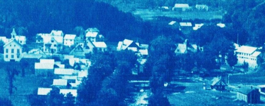
The Lower Village from Town Hall to The Tavern
New Boston in 1899
 What did New Boston look like in 1899?
In the Historical Society archives is a handmade photo album containing wonderful photographs of our town. We don't know who the photographer was or whose bold cursive identifies each photo, but the album provides a glimpse into New Boston's past.
The 1890s were a very interesting time in New Boston's history. The town's population had peaked at 1,700 people during the Great Sheep Boom of 1820-1830 and declined steadily for the next 100 years, until there were only 693 New Boston residents in 1930. This decline was seen in many New England towns as young people moved west or went to cities to work in the mills. New Boston's population did not surpass its 1820 peak until the 1980 census!
The Great Fire: In May of 1887, the center of New Boston village burned to the ground. Among the forty buildings destroyed were the Town Hall, the Village School, two churches, a general store and the firehouse. With a declining population and its downtown in ruins, what cause did New Boston have for optimism?
In fact, the decade which followed the Great Fire was an exciting time to live in New Boston. Most of the village center was rebuilt within a year or two of the 1887 fire. The railroad came to town in 1893, connecting New Boston to Goffstown, Manchester, and Boston MA. Each summer, boarding houses welcomed guests from as far away as New York City. A new electric plant provided lighting to streets and businesses. J. R. Whipple's Valley View Farm prospered and employed 90 people to supply his Boston hotels. J.R. also established the Whipple Free Library with 2,000 volumes in his new general store building.
The Photo Album
All of the photos in the album are blue. We believe that they are "cyanotypes", made using a chemical process also used to create blueprints. The photos on this page have been resized; reduced 10x to load more quickly. You may click on the most interesting photos to see a more detailed scan in a new tab. If you move your cursor over the detailed scan, it will look like a plus sign (+) indicating that you can click on the photo to make it bigger or a minus sign (-) indicating "click to make smaller." There may be a scroll bar at the bottom of your screen so you can scroll left or right.
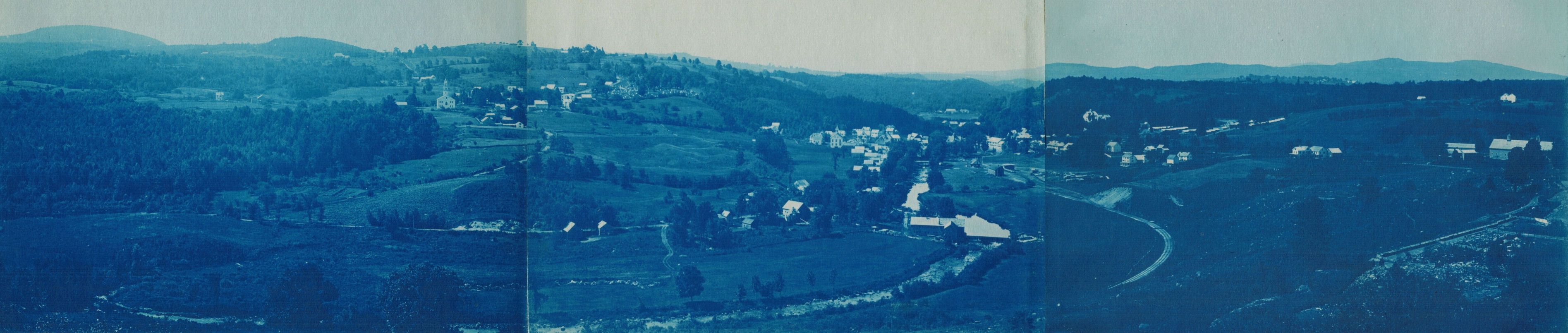
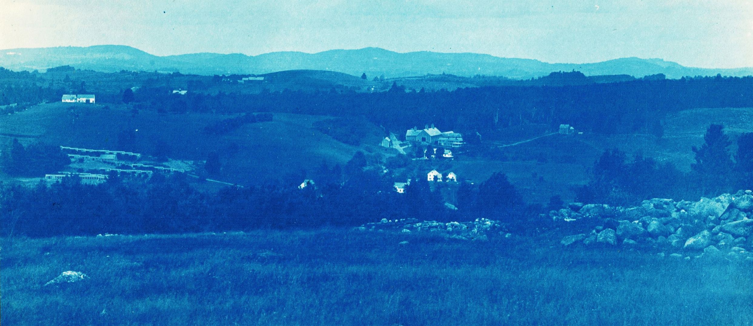
New Boston from Pinball Hill (click photo for more detail)
Pinball Hill is between the 4-H Fairgrounds and the Weare Road (Route 77), and doesn't look much like a pinball today as it's covered with trees. The New Boston landscape was more open in 1899 and the views were better!
Let's point out some details from the panorama that you'll want to study in the larger version.
Details from panorama (these photos are not clickable)
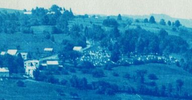
2. Gravestones are visible in the cemetery to the right of the Church on the Hill. In between church and cemetery was New Boston's Upper Village in the 1700s, with shops and taverns. Meetinghouse Hill Road runs along the trees at the bottom of this detail.
3. At the bottom of Meetinghouse Hill, the Lower Village has been rebuilt after the Fire of 1887. From left to right, see the Town Hall, the Village School, and the Baptist and Presbyterian churches. See churches and schools for more information.
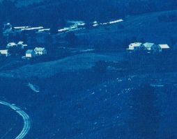
5. Above the railroad depot in this photo is The Tavern on High Street.
6. Most of the righthand panel of the three-photo panorama is J.R. Whipple's Valley View Farm. The narrow henhouses in the top left corner of this detail stood on Valley View Road. The Whipple homestead to the right still stands on the corner of the Francestown and Weare Roads (Routes 136 and 77) and now faces a cement dairy barn that was state-of-the-art when built in 1909.
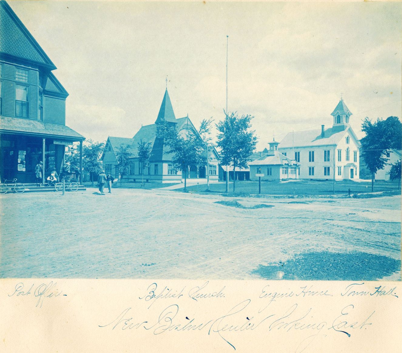
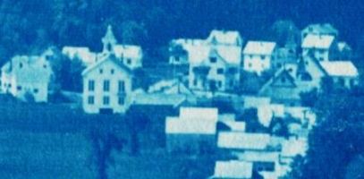
New Boston Center Looking East (click photo for more detail)
 In 1899, what is now Dodge's General Store (leftmost building in photo above)
was operated by Solomon D. Atwood, whose family may have made this photo album.
The Post Office was in the east corner of the store nearest the men.
In 1899, what is now Dodge's General Store (leftmost building in photo above)
was operated by Solomon D. Atwood, whose family may have made this photo album.
The Post Office was in the east corner of the store nearest the men.
Across River Road, the large Baptist Church and horse sheds stand next to the "Engine House" or fire station that is now the Recreation Department office, near the Town Hall.
The bicycles parked at the store look suspiciously modern but an 1899 Schwinn catalog confirms that dropped handlebars were indeed available then.
The west side of the general store contained the Whipple Free Library. The library collection moved across the street when the Wason Memorial was built in 1927, and by World War II the Post Office occupied this space in Dodge's Store.
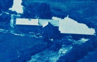
 The Creamery and the Old Church on the Hill
J.R. Whipple built a modern creamery to process milk from many farms around New Boston. Farmers were paid by the "space", a measure of the cream content of the milk.
Click on the photo to see a more detailed scan; notice the clothes dryer in the foreground and the horse-drawn carriage parked by the Creamery.
The Baptist Church is hidden behind the Creamery - only its horse sheds are visible - and the Engine House and Town Hall are just off-camera to the right.
Meetinghouse Hill Road climbs up towards the Old Church and then makes a sharp right towards the cemetery (also off-camera).
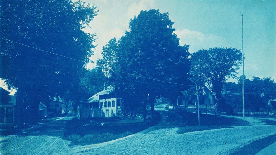
New Boston Center Looking West
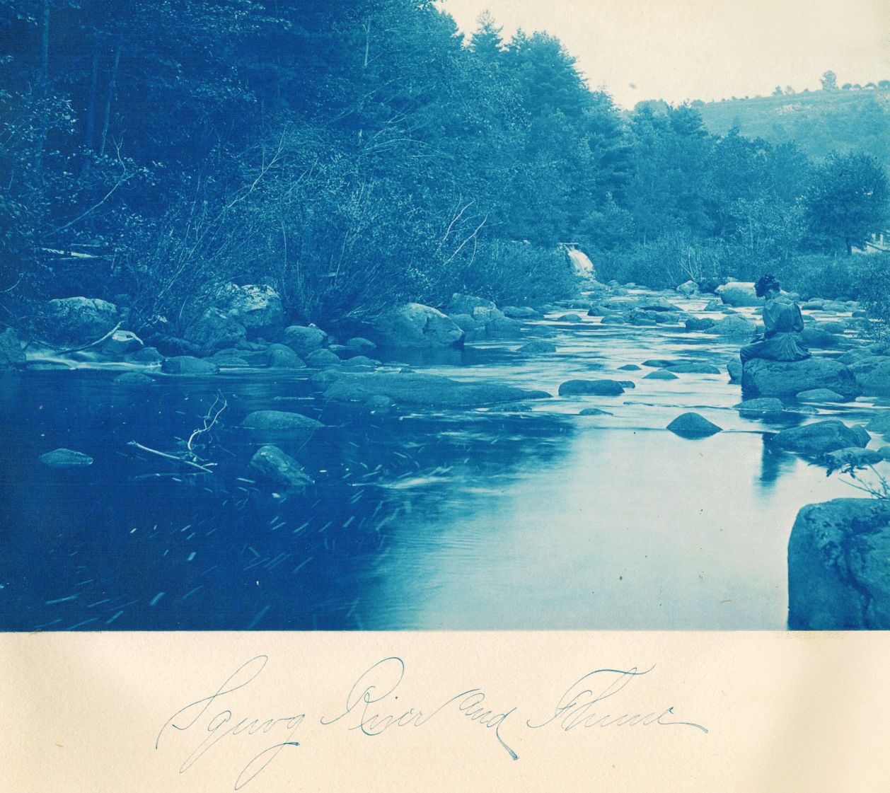 Squog River and Flume
We posted a detailed scan of this photo on the New Boston Facebook page to see if anyone recognized its location on the Piscataquog River. (Click photo for more detail.) The general consensus was that it's just upstream of the Sutherland mill (later Walt Kirsch's mill). We did try to confirm this by wading up the river, trying to locate specific boulders, but the floods of the 1930s must have rearranged the rocks.
If you park by the new Post Office and go to the nearby bridge, you may see the mill foundation on the west side of Route 13. Several hundred yards upstream is a dam which creates a mill pond. Water from this pond traveled in a man-made canal alongside the river to the mill, and the mill operator could dump this water over a flume back into the river. We think that's the white water to the left of the blue lady's hat.
Looking east from a point halfway between the dam and the mill, the flume location and the skyline near Hooper Hill Road are similar to this photo. There is a photo of the Sutherland mill on the mills page. Is its roof just visible to the right of the lady's hat in the detailed scan?
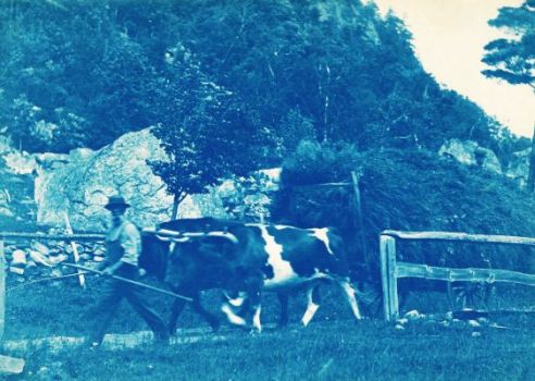
To complete our tour of south New Boston, we'll go down Route 13 towards Mont Vernon by the Hopkins Mill,
then go left on Meadow Road towards the base of Joe English Hill.
The photo of the bearded gentleman with his oxcart is titled "A native at Joe English".
Village from Bradford Hill (click photo for more detail)
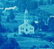
 The Old Church on the Hill
From Bradford Hill we go down Cemetery Road to Bedford Road, where we find the Old Presbyterian Church, built in 1823. We're not sure that a clock was ever installed in the bell tower, but there was an enormous Revere Bell that was moved to the new Presbyterian church in the lower village after the Fire of 1887.
The Church on the Hill was being used for storage by the Atwood family when it was struck by lightning and burned to the ground a year after this photo was taken. See the Churches and Meetinghouses of New Boston page for more information.
(Click photo for more detail... note the three people leaning against the stone wall.)
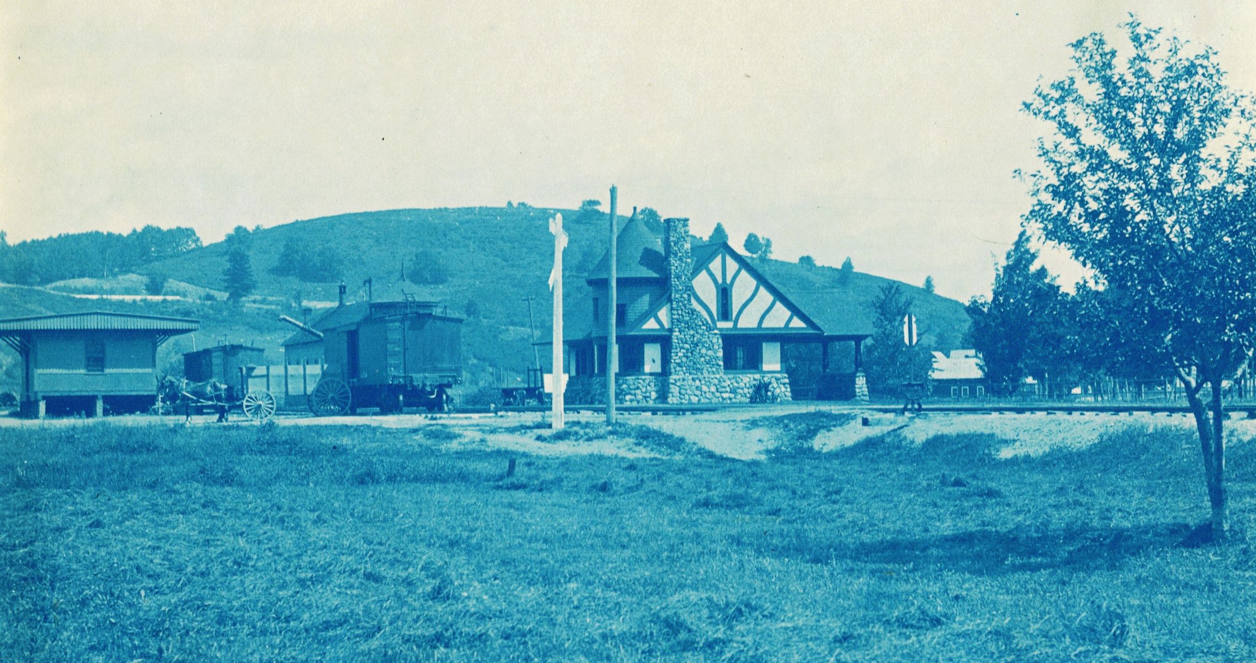
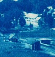
Depot and Pinball (click photo for more detail)
Behind the depot rises the majestic Pinball Hill. You may have expected a tall mountain, since the panorama at the top of this page seems to have been taken from a very high vantage point. But this modest little hill was big enough to be a ski slope from 1947-1953, complete with a rope tow powered by a Ford V-8 engine. Today, Pinball Hill is tree-covered and even less prominent.
While we wait for the passenger train to arrive, let's end our tour of 1899 New Boston with a quick visit to the Valley View Farm piggery.
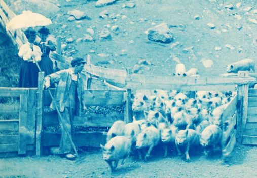
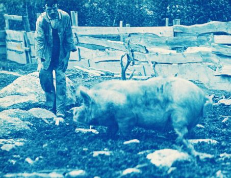
These photos are titled "Meal Time" and "His Majesty the Pig".
Perhaps the fine ladies under the parasol are summer boarders looking to see where their breakfast bacon comes from.
Who made the 1899 photo album?
We don't know. There is no name anywhere in the album. It was given to the Historical Society in 1996 by Bill and Constance Bowe of Billerica. We called Constance in 2015 and asked if she remembered this photo album. She did. Constance thinks she and Bill may have bought it at a garage sale in Reading MA. It caught her eye because she used to visit her relations in New Boston when she was a teenager, in the 1940s. (Ed and Lena Davison had a chicken farm here in New Boston.) Constance doesn't know who made the album, but the Historical Society is delighted that she and Bill thought to give it to us!
We do have two clues:
1. The last page of the album contains a handwritten poem. It specifies neither title nor author. However, after a lengthy search, we found a copy of this poem in an article about New Boston written by Rev. John Erastus Wildey in The Granite Monthly in 1897. It reads in part:
There's many a spot of hill and dale, of valley and mountain height,
Where mirrored surface of river and pond, shimmers the glad sunlight;
Where forests rear their crowns of green 'mid odors of spruce and pine,
And the carpet of needles at their feet is wreathed by a running vine;
Where in cosy nooks in the hillside's steep, and down in the quiet glen,
Nestle the homes that stand out to the world; fair women and noble men.
Rev. Wildey identifies the author as Mrs. Florence A. D. Atwood (1841-1929), wife of Solomon D. Atwood, "whose literary work as poet and correspondent has given her a wide reputation." The 1897 article says that Florence wrote the poem "years ago, for the love she bears this town." Was it Florence or one of her family who created the photo album in 1899?
2. In 1989, Mrs. Amy Miller of Rindge donated to the Historical Society a box containing glass negatives of people and scenes of New Boston in the period 1890-1892. Mrs. Miller had purchased the negatives at an auction near New Boston "years ago". The glass plates are similar in theme and composition to the photos in the 1899 album, although we haven't found an exact match.
The talented photographer was Miss Myrtie Mae Atwood (1868-1949), daughter of Florence and Solomon. She married G. Henry Eastman of Weare, NH in the early 1890s.
If anyone has more information about Myrtie Mae (Atwood) Eastman's interest in photography, or about the photos in our 1899 album, please let us know!