New Boston Historical Society
New Boston, New Hampshire
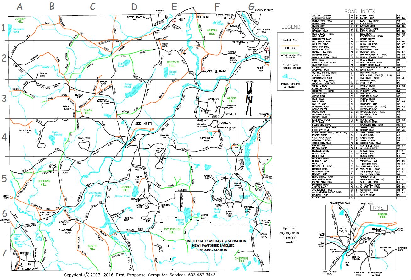
2016 map of New Boston courtesy of Wayne Blassberg
The Names of New Boston's Roads
My brother-in-law, who is something of a Road Scholar, tells me that the definitive study "A Classification of Place Names" was written by George R. Stewart in 1954. Dr. Stewart proposed seven categories, including "euphemistic names" and "folk etymological names" but I'll argue that most New Boston road names belong to one of four categories that are easier to remember:
Roads named for neighboring towns
Naming a road for its destination is a New England tradition. I hope you've noticed that the New Boston road which goes to Bedford is called "Bedford Road" and that its name flips to "New Boston Road" once you're in Bedford. Weare Road goes to Weare and Lyndeboro Road goes to Lyndeborough. Of course, there's always an exception — the road which goes to Goffstown is called River Road.
Today the main road from New Boston to Francestown (Route 136) is called Francestown Road, which should surprise no one. But did you know that Old Coach Road was once called "South Francestown Road" and Clark Hill Road was "Old Francestown Road"?
Route 13 South goes to Mont Vernon so it's called Mont Vernon Road today; a hundred years ago it was called "Amherst Road." Riverdale Road goes to Riverdale, which is a little-known village that straddles the Weare/New Boston town line.
The South Manchester Road won't be found on current maps. It ceased to be navigable when the US Army installed gates at either end and fenced in the military reservation that's now the Space Force satellite tracking station.
Roads named for people
I just mentioned Clark Hill Road... the Clark family once lived up that hill. The bottom of Clark Hill Road was known as Shedd Road for a while when the Shedd family lived there; now Shedd Road is just off Pine Echo Road, leading to a single house where another Shedd once lived. (I don't know how Pine Echo Road got its name — do you?)
The Lull family lent their name to Lull Road, East Lull Place, and West Lull Place. I won't list all the many roads named after people who once lived there; these range from Baker Lane to Woodbury Road. Swanson Road is an example of a new road named after someone significant to our town's history, Reverend Louis Swanson in this instance. An earlier minister, Ephraim Bradford, lived on Bradford Lane with his wife and their twelve children.
Roads named for geography
I mentioned River Road earlier. Joe English Road is named after the granite hill associated with the legend of Joe English. Other "Hill" roads are Briar, Bunker, Chestnut, Clark, Cochran, Hooper, Leach, Meetinghouse, Saunders, South, and Wilson. One might think that New Boston is a hilly town! (See also: Valley View Road and Ridgeview Lane.)
Frog Rock Road is named for an oddly-shaped rock. Scobie Road leads to Scoby Pond in Francestown; yes, they're spelled differently. Shaky Pond Lane is one of several "Pond" roads in New Boston. Bog Brook Road and Indian Falls Road are named after other watery features.
Roads with historic names
New Boston's first settlers built their homes and a church near First Settlement Lane, and then gave up for fear of hostile Indians. North Mast Road (Route 114) was used in the 1700s for tall pine trees to be dragged to the Merrimack River and floated to the sea for use as masts in the King's Navy.
The Second New Hampshire Turnpike was built around 1800 in a mostly-straight line from Amherst to Claremont; there was a "pike" or tollgate at the New Boston / Mont Vernon town line.
"Mill" roads include Butterfield, Gregg, and Tucker, plus Mill Street in the village center. Town Farm Road was the site of the town's Poor Farm in the 1800s. The New Boston Railroad is long gone but its depot still stands on Depot Street.
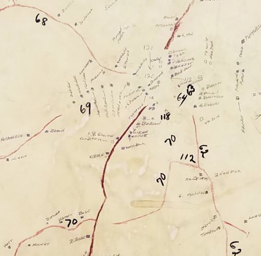
The "plywood map" shows road numbers used from 1943 to the 1980s
Although New Boston's roads didn't have official names, the Highway Agent needed an efficient way to manage their maintenance and snowplowing, so he numbered all the roads in the early 1940s. In the museum we have his "plywood map" showing these numbers — it's a paper map mounted on plywood, which once hung in Town Hall — and a stack of index cards relating residents' names to their road numbers. Clark Hill Road was "68", Old Coach Road was "69", and Hooper Hill Road and Lyndeboro Road were "70". Of course, these numbers were not easy for townspeople to remember.
In 1953 the Planning Board announced that Mr. and Mrs. Charles Gould had been "asked to work with the Board to name the roads in New Boston that signs may be made and erected in the future. A map has been made and will be presented at Town Meeting for approval."
Charles and Mary Louise Gould formed a committee of volunteers to help them with this project, and the Historical Society is fortunate to have some of their files. Included was a letter to the Goulds from George White, a newcomer to town, emphasizing the need for road signs: "I have seen very few boards with names [road signs] and some of those were on the ground, and for the most part, when I tell anyone that I live on Bedford Road, they ask, 'Where is Bedford Road?'"
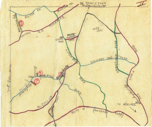
Map on tracing paper with suggested road names for Section IV in the southwest corner of town.
Note that the lower part of Old Coach Road was known as "Stanley Hill Road"; the cellar holes of Stanley's house and barn are still visible today.
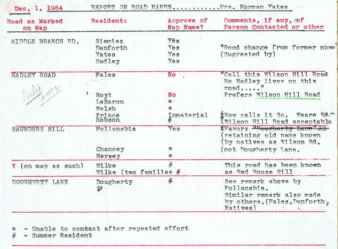
Report submitted by Mrs. Norman Yates
Mrs. Yates left us a typed report and a letter to Mrs. Gould: "I have done this to the best of my ability, but after I started I realized that I was at quite a disadvantage as I do not know hardly any of the people, or for that matter, who lives on the various roads!"
I thank Mrs. Yates and the Goulds for their good work, and invite you to share your stories of road names with the Historical Society.
— Dan R. townfarm@comcast.net
New Boston Street Addresses — Why My House is Number 66
Now that we know where road names come from, what about the numbers we put on our mailboxes? The answer to the house number mystery involves John Bunting and his surveyor's wheel.
John was a volunteer fireman – in fact our fire station is named in his memory – and he wanted a scientific numbering system for our town
so that the fire and rescue services would know exactly where to go when they got a call.
For example my street address, 66 Town Farm Road, tells you how far down the road my house is from the intersection with Old Coach Road.
The answer to the house number mystery involves John Bunting and his surveyor's wheel.
John was a volunteer fireman – in fact our fire station is named in his memory – and he wanted a scientific numbering system for our town
so that the fire and rescue services would know exactly where to go when they got a call.
For example my street address, 66 Town Farm Road, tells you how far down the road my house is from the intersection with Old Coach Road.
Wayne Blassberg lent me a copy of the Bunting Bible, the 7-page document in which John defined how houses should be numbered. John wrote, "Measure the distance to a house or lot from the beginning of the road, then divide the distance in feet by 3.28084 and that will provide the meters. The person's address is based on meters divided by 10!!! Round up or down as appropriate."
My house is 2,162 feet from Old Coach Road, which when converted to meters and divided by 10 equals 65.9, which rounds up to 66. Of course I asked Merry Bunting, "Why meters?" and she said that at the time John wrote his instructions people thought America would convert to the metric system, which never happened. I vaguely remember when highway signs listed both miles and kilometers; this may have been in the late 70s or early 80s.
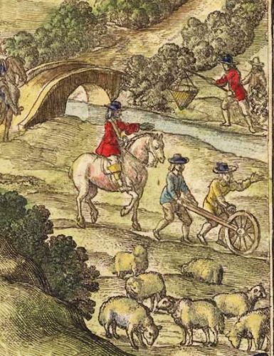
Two men using a surveyor's wheel to measure distance; 17th-century drawing from Wikipedia
John Bunting had to determine where to begin counting, i.e. from which end of any given road, and there are many paragraphs in his document defining the rules. Wherever possible John liked to begin at the north-south "cardinal" roads: Weare Road and Mont Vernon Road, or east-west cardinal roads: Clark Hill Road and Bedford Road. If you look at a map you'll see that these roads divide New Boston into four quadrants.
John wrote pages and pages about special cases and exceptions and subdivisions, and reminded road namers that "if a road is a dead end, it shall be named 'lane' or 'drive.' 'Road' and 'street' are for through roads." He also recommended that new roads be given names of historical significance – "Some good sources of possible names are Frances and Howard Towne, Paula LeBaron and the Historical Society." If you are building a new road or lane, do give us a call!
I am grateful to John Bunting for his years of service to our town. I should also mention Jim Dodge, our Fire Chief for many years, who would get the phone calls, "Why is there a strange man pushing a wheel down my road?" — Dan R. 2023